Top 5 Mountains in the world
01 Mount Everest
 Height in meter : 8,848
Location : Nepal/China (Tibet)
Height in meter : 8,611
Location : Pakistan/China
Height in meter : 8,848Location : Nepal/China (Tibet)
The current official elevation of 8,848 m (29,029 ft), recognized by China and Nepal, was established by a 1955 Indian survey and subsequently confirmed by a Chinese survey in 1975. In 2005, China remeasured the rock height of the mountain, with a result of 8844.43 m (29,017 ft). There followed an argument between China and Nepal as to whether the official height should be the rock height (8,844 m., China) or the snow height (8,848 m., Nepal). In 2010, an agreement was reached by both sides that the height of Everest is 8,848 m, and Nepal recognizes China's claim that the rock height of Everest is 8,844 m.
In 1865, Everest was given its official English name by the Royal Geographical Society, upon a recommendation by Andrew Waugh, the British Surveyor General of India. As there appeared to be several different local names, Waugh chose to name the mountain after his predecessor in the post, Sir George Everest, despite Everest's objections.
Mount Everest attracts many climbers, some of them highly experienced mountaineers. There are two main climbing routes, one approaching the summit from the southeast in Nepal (known as the "standard route") and the other from the north in Tibet. While not posing substantial technical climbing challenges on the standard route, Everest presents dangers such as altitude sickness, weather, and wind, as well as significant hazards from avalanches and the Khumbu Icefall. As of 2017, nearly 300 people have died on Everest, many of whose bodies remain on the mountain.
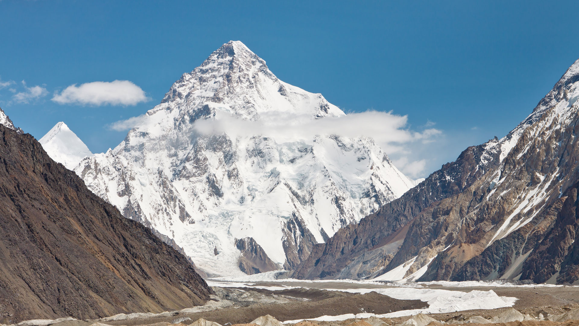
02 K2
Height in meter : 8,611
Location : Pakistan/China
The name K2 is derived from the notation used by the Great Trigonometric Survey of British India. Thomas Montgomerie made the first survey of the Karakoram from Mount Haramukh, some 210 km (130 miles) to the south, and sketched the two most prominent peaks, labeling them K1 and K2.
The policy of the Great Trigonometric Survey was to use local names for mountains wherever possible and K1 was found to be known locally as Masherbrum. K2, however, appeared not to have acquired a local name, possibly due to its remoteness. The mountain is not visible from Askole, the last village to the south, or from the nearest habitation to the north, and is only fleetingly glimpsed from the end of the Baltoro Glacier, beyond which few local people would have ventured. The name Chogori, derived from two Balti words, chhogo ("big") and ri ("mountain") (چھوغوری) has been suggested as a local name,[12] but evidence for its widespread use is scant. It may have been a compound name invented by Western explorers[13] or simply a bemused reply to the question "What's that called?" It does, however, form the basis for the name Qogir (simplified Chinese: 乔戈里峰; traditional Chinese: 喬戈里峰; pinyin: Qiáogēlǐ Fēng) by which Chinese authorities officially refer to the peak. Other local names have been suggested including Lamba Pahar ("Tall Mountain" in Urdu) and Dapsang, but are not widely used.
Comments
Post a Comment